.jpg)
Atlas of Township Patent Maps of Westmoreland County, PA (527 pages)
and Companion Detailed Tract Maps CD (.pdf files)
Atlas: Although the Pennsylvania Land Office did not plat the surveys onto Township Warrantee Maps as they did for about 1/3 of the townships in the state, we are exceedingly fortunate that the Map Maintenance Department located in the Westmoreland Co. Courthouse completed a similar project to map the patents of the original tracts about 10 years ago. They created an overview of each township showing each plat within the township, as well as 353 Detailed Tract Maps (see below; these detailed maps are contained on the companion CD, while the township maps are contained in the atlas) which show the original tracts superimposed over current roads, towns, subdivisions, etc. We transcribed all of the information shown on each tract on these maps for this volume in our Early Landowners of Pennsylvania series. The main difference between the early landowner maps produced by the state and the county-produced Detailed Tract Maps is that Westmoreland County drafted patentee maps rather than the warrantee maps that the state produced. Because of this difference, the names of the original warrantees were often omitted from the data on the maps, necessitating more research on our part. Thus, we looked up the original warrantee and patentee for each tract (about 4,000 of them!) in both the Westmoreland Co. Warrant Register in Harrisburg (this site explains the difference between warrantees and patentees) as well as the relevant Patent Register Index in Harrisburg. If a New Purchase Application of 1769 was associated with the tract, we also included the entire description of the land found in the New Purchase Register in Harrisburg.
We found a great deal of conflicting information between what is on the Detailed Tract Maps, the Westmoreland Co. Warrant Register and the Patent Register Indexes, in part because it appears that some of the tracts were drawn using Deed Book references within the Westmoreland Co. Courthouse and somewhat later information, while the majority were constructed using the Warrant and Survey Registers on file in Harrisburg. With the information in the township charts in the atlas, you will be able to locate your ancestor's tract, as well as to know which repository in Greensburg or Harrisburg holds the original documents so that you may request copies of them.
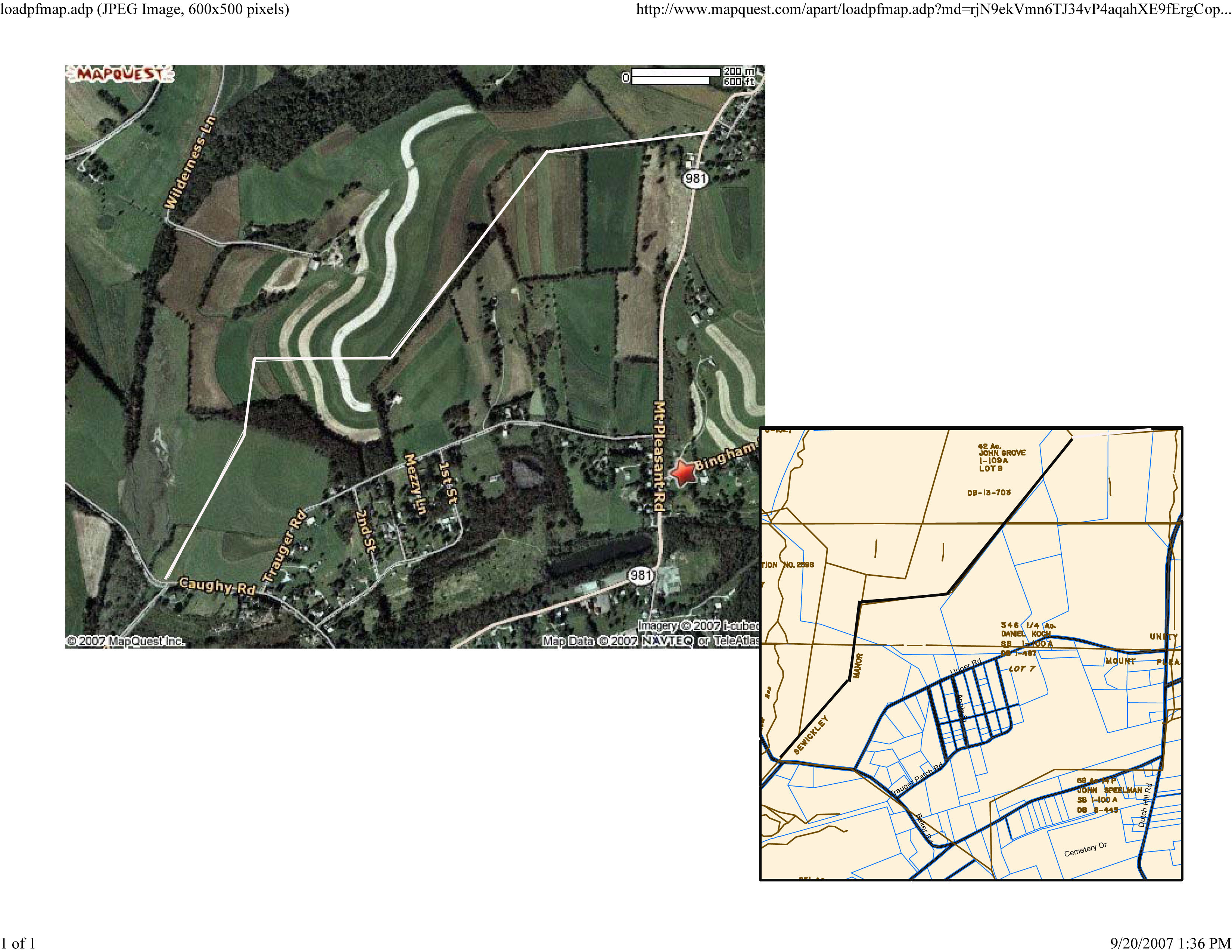
Companion CD: The Detailed Tract Maps produced by Westmoreland County are truly a unique tool for researchers of Westmoreland Co. settlers. These 353 detailed maps, which are not included in the book above, show the original tracts superimposed over modern maps. Consequently, you can locate precisely where your ancestor’s land was and see the roads and lots within it today. For example, my ancestor, Daniel Koch, who is on the 1790 census of Allen Township, Northampton County and moved here between 1791 and 1792, is shown in the upper left portion of Detailed Tract Map #243 below (click to enlarge).
.jpg)
Next, I located Daniel Koch’s tract on MapQuest using the roads listed on the Detailed Tract Maps. Then I clicked on “Aereal Image” which gave me the image below.
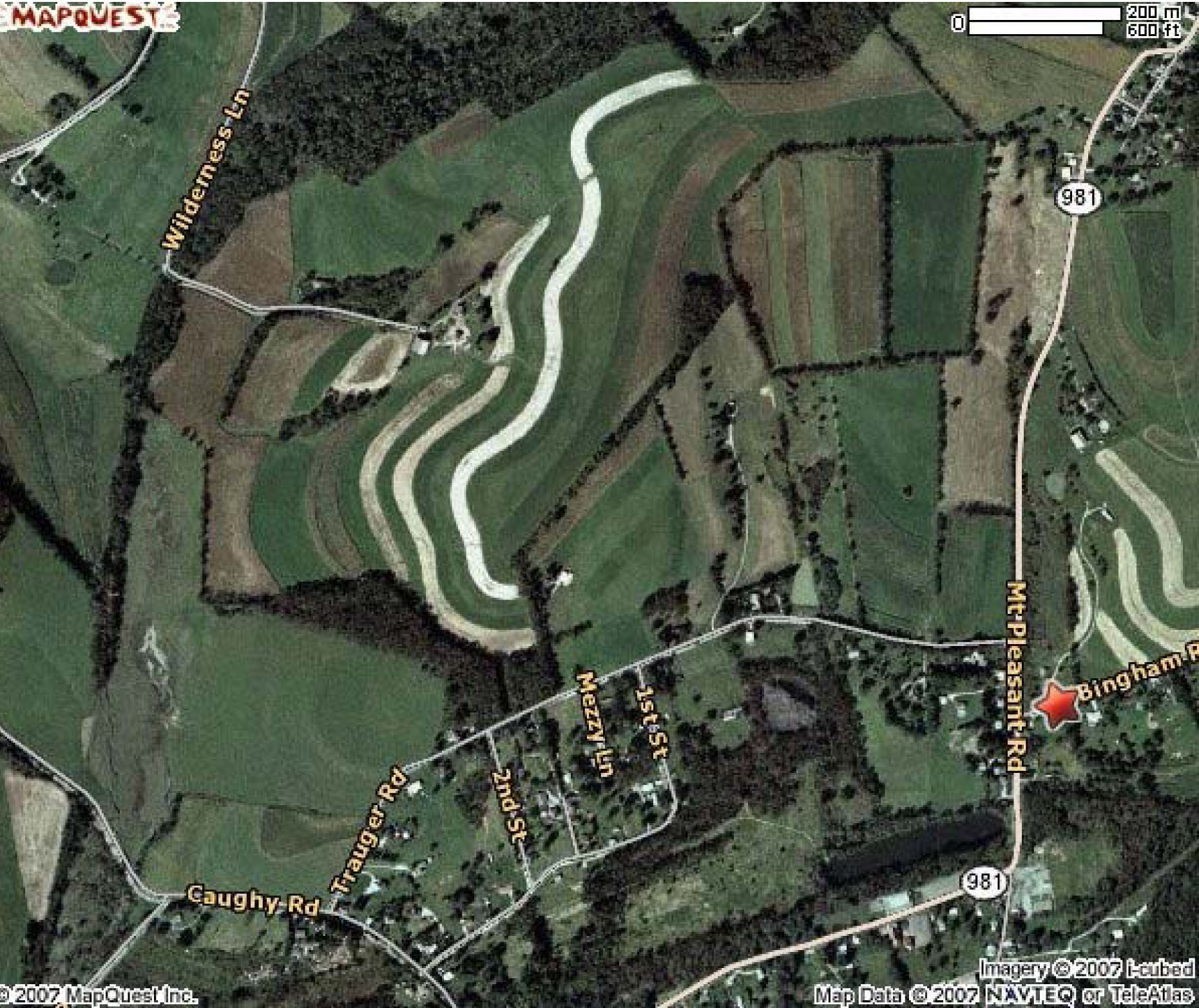
If you look carefully at the aerial map on MapQuest, you will see that there are actually straight lines of vegetation. It is amazing that many, if not most, of today’s roads and straight lines of trees or shrubs actually follow the outlines of those old tracts, and I was able to take advantage of the straight rows of shrubs and trees and ploughed fields, plus the roads which define two sides of his property, to draw Daniel Koch’s tract as follows:
Keep in mind that Westmoreland Co. originally encompassed far more territory than it does today, but this atlas includes only the boundaries of present Westmoreland County. Also note that after receiving land from the state or colony of Pennsylvania, all subsequent land sales and transfers were recorded in county courthouse covering the area at the time.
Finally, for those with ancestors in the 1850 and 1860 Westmoreland County census, we are also presenting complimentary images from Map of Westmoreland Co. Pennsylvania from Actual Surveys by D. J. Lake & N. S. Ames which was published by Wm. J. Barker in 1857. Two different hand-colored copies of this map are located in the Library of Congress Geography and Map Division Washington, D.C., so you will see different coloration depending on which map we used. We hope that these 1857 landowner maps will be a useful tool for locating your Westmoreland County families when coupled with the 1860 census.
Also, be sure to check out the ongoing Westmoreland Co. History Project which is committed to the transcription of the 3-volume (2,000 pages) History of Westmoreland County that was written in 1906 by John N. Boucher & John W. Jordan. This project is being coordinated by Nathan Zipfel who can use more volunteers to complete this massive job. Also, the 1867 Atlas of Westmoreland County, Pennsylvania is posted at USGenWeb Archives. Click on the township of your choice below. Once the images are loaded, they can be enlarged by clicking on them, and they may be saved to your computer by right-clicking and selecting "Save Image As..."
Click here to go to the order form.
Click here to go to the product page.
Click here to return to the home page.